Ecologically or Biologically Significant Areas (EBSAs)
Charlie-Gibbs Fracture Zone
Fracture zones are common topographic features of the global oceans that arise through plate tectonics. They are characterized by two strongly contrasting types of topography. Seismically active transform faults form near mid-ocean ridges where the continental plates move in opposing directions at their junction. Seismically inactive fracture zones, where the plate segments move in the same direction, extend beyond the transform faults often for 100s of kilometres. Their atypical crust thickness that can be as little as 2 km (Mutter et al. 1984, Cormier et al. 1984, Calvert and Whitmarsh 1986) allowing direct seismic investigations of the internal structure and composition of oceanic crusts used to model processes of seafloor spreading. In the Atlantic Ocean most fracture zones originate from the Mid-Atlantic Ridge (MAR) and are nearly perfectly west - east oriented. There are about 300 fracture zones occurring on average every 55 km along the ridge, with the offsets created by transform faults ranging from 9 to 400 km in length (Müller and Roest 1992).
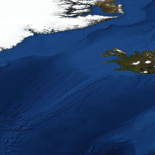
The Charlie-Gibbs Fracture Zone (CGFZ) is an unusual left lateral strike-slip double transform fault in the North Atlantic Ocean along which the rift valley of the MAR is offset by 350 km near 52º30′N (Figure 1). It opens the deepest connection between the northwest and northeast Atlantic (maximum depth of approximately 4500 m; Fleming et al. 1970) and is approximately 2000 km in length extending from about 25°W to 45°W. It is the most prominent interruption of the MAR between the Azores and Iceland and the only fracture zone between Europe and North America that has an offset of this size[1]. Knowledge of its geomorphology is considered essential to the understanding of the plate tectonic history of the Atlantic north of the Azores (Olivet et al. 1974). For these reasons it is a unique geomorphological feature in the North Atlantic; further, it captures the Earth’s geological history, including significant on-going geological processes.
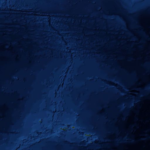
The CGFZ comprises two narrow parallel fracture zones (Fleming et al. 1970), which form deep trenches located at 30ºW (Charlie-Gibbs South Transform Fault) and 35º15′W (Charlie-Gibbs North Transform Fault) and separated by a short (40 km) north-south seismically active (Bergman and Solomon 1988) spreading centre (median transverse ridge) at 31º45’W (Figure 2; Searle 1981; Fleming et al. 1970, Olivet et al. 1974). The southern fault displaces the MAR, coming from the Azores, to the west over 120 km. It is at most 30 km wide (Searle 1981). The northern fault displaces the spreading ridge over another 230 km to the west before it connects to the northern part of the MAR going to Iceland. Both transform faults continue eastward and westward as inactive fracture zones (Figure 2).
The CGFZ is characterized by rough morphology, and the walls of the fracture valleys and the ridge in between them are broken and irregular, with slopes of up to 29° (Fleming et al. 1970). The height of the ridge between the faults is at least 1000 m below the surface and as shallow as 636 m in parts (Fleming et al. 1970). Rock samples show the walls of the fracture zone to be both basaltic and ultramafic while the median transverse ridge contains gabbro (Hekinian and Aumento 1973). Earthquake epicentres are associated with the transform faults (Kanamori and Stewart 1976, Bergman and Solomon 1988), and an almost continuous belt of epicentres follows the southern end of the Reykjanes Ridge, along the northern transform valley, the central median valley and the southern transform valley to the north end of the MAR (Lilwall and Kirk 1985). Two named seamounts are associated with the transform faults: Minia Seamount (53°01′N 34°58′W), located near the junction of the Reykjanes Ridge and the northern transform fault, and Hecate Seamount (52°17′N 31°00′W), located on the northern wall of the southern transform fault east of the short median transverse ridge.
Ridges and troughs along the CGFZ are mostly covered with muddy sediments (Fleming et al. 1970), although outcrops of sedimentary rock and boulder fields are exposed by recent faulting and current scour (Shor et al. 1980, Searle 1981), and the southern transform near 30°30′W has no sediment cover (Searle 1981). Thick layers of sediment are deposited in the northern transform valley from the Iceland-Scotland Overflow Water (ISOW), which carries a significant load of suspended sediment (25 μg I-1) as it passes through (Shor et al. 1980). Transverse ridges prevent the sediment from reaching the southern valley (Searle 1981), which has less sediment cover, although it is still considered a depositional environment (Shor et al. 1980).
The topography of the CGFZ has a major influence on deep-water oceanographic circulation (Harvey and Theodorou 1986). A large component of the North Atlantic Deep Water originates in the Norwegian Sea and flows south over the sills between Scotland and Iceland (ISOW). It meets the CGFZ near the intersection of the transform faults and the spreading centre (Shor et al. 1980). There is then a westward movement of deep water passing through the fracture zone from east to west through to the Irminger Sea occurring from the core depth of the ISOW at about 2500 m to the sea floor (Garner 1972, Shor et al. 1980, Saunders 1994). Most of this water is carried through the northern transform fault where the overflow water first encounters the fracture zone.
The topography of the CGFZ also is thought to have some influence on the circulation of surface waters, although they are not locked to the bottom features to the same extent as the ISOW (Rossby 1999, Bower et al. 2002). The northern branch of the North Atlantic Current defines the location of the sub-polar front between colder Sub Arctic Intermediate Water to the north and warmer North Atlantic Intermediate Water to the south (Søiland et al. 2008). The sub-polar front meanders between 48-53°N, and surface flow is predominantly eastward. The CGFZ is therefore not only a topographic discontinuity in the MAR but the area also constitutes an oceanographic transition zone between waters of different temperatures and flow regimes (Priede et al. 2013).
This proposal concentrates on an area that is an especially complex section of the MAR (Søiland et al., 2008), including sections of the MAR to the north and south of the Charlie-Gibbs Fracture Zone, and as such is expected to be home to diverse and interesting deep-sea fauna (Tabachnick & Collins, 2008). From the north, the Reykjanes Ridge stretches southwestwards from Iceland to approximately 52ºN, where the Charlie-Gibbs Fracture Zone (Felley et al., 2008; Heger et al., 2008) offsets the ridge by 5º to the east and opens the deepest (maximum depth 4500 m) connection between the northwest and northeast Atlantic (Felley et al., 2008; Heger et al., 2008; Mortensen et al., 2008; Søiland et al., 2008). South of the Charlie-Gibbs Fracture zone, two pronounced deep rift valleys at 32.25ºW and 31.75ºW (Opdal et al., 2008) and two further fracture zones (Faraday and Maxwell Fracture Zones, at 50ºN and 48ºN respectively) create topographic complexity that likely also creates associated diversity in ecological communities, although the latter remain poorly characterised.The MAR within the OSPAR maritime area is considered to have three different biogeographic regions. The MAR-ECO project studied these areas in their fieldwork, by targeting three clear areas in the northern, southern and Charlie-Gibbs Fracture Areas regions. The on-going ATLAS project is completing a revision of North Atlantic biogeography, including work to understand the implications of changing ocean conditions (ATLAS 2019).
The general circulation in the epipelagic zone (0-200 m) is well understood as the warm North Atlantic current flowing north-eastwards from the subtropical gyre in the southwest Atlantic towards the European shelf with two to four branches crossing the MAR between 45° and 52° N, approximately coinciding with the three fracture zones (Sy et al. 1992, Søiland et al., 2008). The sub-polar front is created where the warm, saline North Atlantic water meets the cold, less saline water of the sub-polar gyre from the Labrador and Irminger Seas and is a permanent feature. The meandering of the sub-polar front between 48-53°N coincides with temporal variation in the character and spatial distribution of the water masses and frontal features (Søiland et al. 2008). This front is one of the major oceanic features in the OSPAR region, being an area of elevated abundance and diversity of many taxa, including an elevated standing stock of phytoplankton (Clark et al., 2001; Gallienne et al., 2001; Gaard et al., 2008; Opdal et al., 2008; Sutton et al., 2008).
This area extends from 48°N and 55°188′N along the Mid-Atlantic Ridge, and the Charlie-Gibbs Fracture Zone occurs at 52º30′N. The area extends from about 25°W to 45°W, with the transform faults occurring between 30°W and 35°W (Olivet et al. 1974). The eastern boundary of the Charlie- Gibbs Fracture Zone is detectable beyond 42°W. The southern ridge continues uninterrupted to 45°W (Olivet et al. 1974). This area encompasses the Charlie-Gibbs Fracture Zone, the meandering Sub-polar Frontal Zone and the benthic communities of the Mid-Atlantic Ridge in this area, including individual seamounts.


The MAR is a benthic feature and has important benthic habitats associated with it. However, as mentioned in the introductory section, the MAR plays a fundamental role in circulation patterns of the area and so can also be considered a water column feature. The Charlie-Gibbs Fracture Zone (CGFZ) is a unique geomorphological feature to the North Atlantic Ocean and to the high-seas areas of NEAFC and OSPAR. Owing to its remoteness, the fauna associated with the CGFZ are poorly studied, and it is premature to speculate on whether any species are endemic based on first descriptions. For example, Gebruk (2008) described two species of holothurians and believed them to be endemic to the MAR but they subsequently were found on the European continental margin in the Whittard Canyon (Masson 2009).
As part of the MAR-ECO project (Priede et al. 2013) manned submersibles were deployed on the axis (52°47′N) and the northern slopes (52°58′N) of the Charlie–Gibbs North transform fault and surveyed macroplankton (Vinogradov 2005), demersal nekton (Felley et al. 2008) and invertebrate megafauna (Gebruk and Krylova 2013). Pelagic shrimps, chaetognaths and gelatinous animals were numerically dominant in the plankton, with peak densities corresponding to the main pycnocline. Mucous houses of appendicularians were abundant at 150 m above the seabed, although this is common throughout the central Atlantic and not associated with specific bottom topography (Vinogradov 2005). Nekton included large and small macrourids (Coryphaenoides spp.), shrimp (infraorder Penaeidea), Halosauropsis macrochir, Aldrovandia sp., Antimora rostrata, and alepocephalids (Felley et al. 2008).
Glass sponges were common between 1700 and 2500 m while the deeper parts of the fracture wall and the sea floor were dominated by isidid corals, other anthozoans, squat lobsters and echinoderms, especially holothurians. The elpidiid holothurian, Kolga nana, occurred at high density in the abyssal depression (Gebruk and Krylova 2013). Rogacheva et al. (2013) recorded 32 holothurian species from the CGFZ area through the ECOMAR project (http://www.oceanlab.abdn.ac.uk/ecomar/), including three elasipodid holothurian species new to science.
In general, none of the fauna documented from the CGFZ showed distributions atypical of similar habitats in the broader North Atlantic, although Gebruk and Krylova (2013) discuss the known distribution of the holothurian Peniagone longipaillata and remark on the differences in relative abundance observed between the occurrence of this species, where it is common in the lower bathyal of the CGFZ, and the continental slopes in the Porcupine Seabight and Abyssal Plain areas and Whittard Canyon, where it is less common. There is weak evidence that the CGFZ may be important for juvenile zoarcids based on a high percentage of those observed with baited cameras being <100 mm in length (Kemp et al. 2013).
General knowledge of seafloor benthos suggests that where the geo-morphological processes of the fracture zone have created steep walls along the fractures, the greater three-dimensional topographic complexity, combined with the strong water flows through the fractures, creates habitat that is likely to be more productive and support greater concentrations of fragile taxa such as deep-water corals and sponges than adjacent habitats (Miller et al. 2012). The sampling done along the fracture zone supports these inferences but the differences from other habitats in similar depths and latitudes have not been quantified yet. The CGFZ was mapped for the first time in 2015 on the RV Celtic Explorer as one of the key projects launched by the Atlantic Ocean Research Alliance, following the signing of the Galway Statement on Atlantic Ocean Cooperation between Canada, the EU and the US in May 2013, discovering sponge gardens and a skate nursery at 2000m.
For the benthic fauna, the Mid-Atlantic Ridge can serve as a barrier for east-west dispersal (see e.g., Mironov & Gebruk 2002, 2006) although the degree to which east and west communities differ varies along the ridge (Alt et al., 2019). Gebruk et al. (2006) noted that particularly in the area south of the CGFZ, 48 per cent of the 150 identified species occurred only to the west of the ridge, whereas 19 per cent of the species were restricted to the eastern Atlantic. Likewise, the CGFZ acts as a barrier in north-south direction: the areas south and north of the CGFZ share only 27 per cent of the species (of the groups used as indicators), and recent studies suggest that the CGFZ may serve as a major biogeographic barrier for deep-sea demosponges (Cárdenas and Rapp, 2015). Due to the transition of water masses at 800-1000 m depth there is also a vertical zonation of the bathyal fauna.
Video inspections in the areas south and north of the CGFZ found cold water corals at all sites, at depths of 772-2355m, most commonly between 800 and 1400 m. Twenty-seven of the 40 coral taxa were octocorals, among which the Gorgonacea were the most diverse (Mortensen et al., 2008). Molodtsova et al. (2008) found very little overlap in species composition of the coral fauna in the sampling areas north, near and south of the CGFZ. The number of megafaunal species was higher in areas where corals dominated, compared to areas without coral. Typical taxa that co-occurred with Lophelia were crinoids, certain sponges, the bivalve Acesta excavata, and squat lobster (Mortensen et al. 2008). In addition, further surveys have also observed sponge aggregations. Bell et al., (2016) observed areas dominated by both demosponges and glass sponges on steep slopes between 2095 and 2601 m depth. Alt et al. (2019) also reported sponge aggregations on flat areas and sedimented slopes at around 2500m depth.
The biogeography of the seamount-related fish fauna of the North Atlantic, caught mainly as bycatch in roundnose grenadier (Coryphaenoides rupestris) and alfonsino (Beryx splendens) trawls down to 1500 m depth in over 20 years of commercial exploitation by Russian fisheries, is described by Kukuev (2004). He accounts for 68 species of mainly mesobenthopelagic bathyal fishes associated with the seamounts of the northern MAR (45-55°N, i.e. within the described area), including 44 species of deepwater sharks, such as Chlamydoselachidae, Pseudotriakidae, Scyliorinidae and Squalidae, including leafscale gulper shark (Centrophorus squamosus), gulper shark (C. granulosus) and Portuguese dogfish (Centroscymnus coelepis).
The ecosystem associated with the MAR seems to be of particular importance to sei (Balaenoptera borealis) and sperm whales (Physeter macrocephalus). The highest aggregations of baleen whales and especially sei whales were observed north of and in relation to the CGFZ, which overlaps with earlier observations of Sigurjónsson et al. (1991) (in Skov et al. 2008). Balaenoptera borealis in particular was most abundant over the slopes of steep seamounts and water depths between 1500 and 3000 m, whereas P. macrocephalus were most common in waters shallower than 2000 m and often seen above high rising seamounts where they presumably found the best feeding conditions, i.e. the highest squid density (Nøttestad et al. 2005). Tracking studies of sei, fin and blue whale have described the migration of these species through the area from the Azores to foraging areas in the Labrador Sea as well as Greenlandic and Icelandic waters (Olsen et al. 2009, Silva et al., 2013; Prieto et al., 2014), Furthermore, fin and blue whales remained at middle latitudes along their migration in the area for prolonged periods in the areas of the CGFZ and Reykjanes Ridge, exhibiting area-restricted search (ARS) behaviour, indicative of foraging activity. The 2004 MAR-ECO expedition, which provided the opportunity to model the oceanic distributions of cetaceans across the CGFZ and Reykjanes Ridge for sperm whales, suggests that these species are associated with fine-scale frontal processes interacting with the topography in the upper 100m of the water column just north of the Sub-Polar Front (SPF), CGFZ and Faraday Seamount (Skov et al., 2008).
The MAR-ECO cruise provided a snapshot of seabird distribution along the MAR in summer 2004: 22 species of seabirds were identified, however only the northern fulmar (Fulmarus glacialis), great shearwater (Puffinus gravis) and Cory´s shearwater (Calonectris diomedea) were observed by the hundreds. The distribution of these species reflects the broad characters of water masses in the area (from Mar-Eco cruise report, Nøttestad et al., 2004) and in particular the boundary effect of the frontal zone and the limited nesting sites available only on the Azores and Iceland (Skov et al. 1994). F. glacialis were distributed along most of the study transect north of 47° N, and they were by far the most common species of seabird along the central and northern parts of the MAR. Densities were generally below 1 bird per km2, and no large-scale concentrations were noted. However, discrete elevations in densities were recorded both in the Reykjanes and the CGFZ regions. P. gravis were observed only in the vicinity of the Subpolar front just north of the CGFZ. Most of the birds recorded were found in the area of the Subpolar front, where concentrations of both sitting and flying birds were observed. The largest flock seen was of 160 birds, but flock sizes were generally between three and 10 birds. Outside the frontal area P. gravis were mainly seen in singles. C. diomedea on the other hand is found only south of the P. gravis distribution area – usually not in flocks except for an area where warm Gulf Stream water surfaced. C. diomedea were commonly observed with cetaceans, most notably dolphins, but also with other species, e.g., sperm whales. More recent at-sea surveys confirm the importance of the area for species richness, abundance and over-wintering aggregations (Bennison and Jessopp, 2015; Boertmann, 2011) as well as for breeding birds from the Azores (i.e., birds travelling there during the incubation period) (Magalhaes et al., 2008).
There is only anecdotal evidence on the observation of sea turtles over the MAR, in particular, enhanced abundances over the CGFZ and SPF regions. The leatherback turtle (Dermochelys coriacea) can be found foraging at oceanic fronts during their long trans-Atlantic migrations (Eckert, 2006). It occurs within the described region and feeds primarily on gelatinous zooplankton (Hays et al., 2006; Doyle, 2007, Doyle et al, 2008), high concentrations of which have been recorded several times around the CGFZ and SPF (Fock et al., 2004; Youngbluth et al., 2008). One study has tracked individuals to the SPF area of the North-East Atlantic, presumably to feed in this plankton rich environment (Ferraroli et al., 2004; Hays et al., 2004). It is probable therefore, that this species of turtle visits the described area to feed. Loggerhead turtle (Caretta caretta) is the most common sea turtle in the North-East Atlantic (Revelles et al., 2007). No direct observations of this species have been made near the CGFZ . However, it is known to make trans-Atlantic migrations between nesting and foraging sites (Encalada et al., 1998). It is possible that animals may stop to feed in the CGFZ during these migrations as noted for individual D. coriacea.
Given the geophysical nature, location and size of the CGFZ, it is unlikely that it will be affected by human activities, although there is potential for mining of the rare minerals associated with the transform faults. In 2010 the Environmental Ministers of the OSPAR countries officially designated a marine protected area of 145,420 km2 in the southern part of the CGFZ (Figure 3) and adopted “significant and innovative measures to establish and manage the southern part of the originally proposed Charlie-Gibbs Fracture Zone MPA – ‘Charlie-Gibbs South MPA’-, for which the seabed and super adjacent waters are situated in areas beyond national jurisdiction” (OSPAR Commission 2010). That same year (2010) the OSPAR Commission and the International Seabed Authority signed a memorandum of understanding in order to conciliate the development of mineral resources with comprehensive protection of the marine environment. In this MOU, the CGFZ is highlighted as an area where consultation between the two had been initiated. In 2012 OSPAR countries designated “Charlie-Gibbs North High Seas Marine Protected Area”, an area of high seas of approximately 177,700 km2 (OSPAR Commission 2012), complementing the Charlie-Gibbs South MPA established previously (Figure 3).
The scale of the impact that fishing and other human activities have had on the fauna of the CGFZ is at present unquantified and likely to be minor, although fishing has been reported on the Hectate Seamount (ICES 2007). In 2009 NEAFC closed more than 330,000 km2 to bottom fisheries on the MAR, including a large section of the CGFZ, which includes the transform faults and median transverse ridge (http://www.neafc.org/page/closures) (Figure 3).
ATLAS (2019) Deliverable 3.3 Biodiversity, biogeography and GOODS classification system under current climate conditions and future IPCC scenarios.
Bennison A & Jessopp M (2015) At-sea surveys confirm a North Atlantic biodiversity hotspot, Bird Study, 62:2, 262-266, DOI: 10.1080/00063657.2015.1011601
Bergman, E.A. and S.C. Solomon. 1988. Transform fault earthquakes in the North Atlantic: Source mechanisms and depth of faulting. Journal of Geophysical Research 93:9027-9057.
Bergstad, O.A. & Gebruk, A.V. (2008) Approach and methods for sampling of benthic fauna on the 2004 MAR-ECO expedition to the Mid-Atlantic Ridge. Marine Biology Research 4: 160 – 163.
Boertmann D. 2011. Seabirds in the central North Atlantic, September 2006: Further evidence for an oceanic seabird aggregation area. Marine Ornithology 39(2):183-188
Bower, A.S., Le Cann, B., Rossby, T., Zenk, W., Gould, J., Speer, K., Richardson, P.L., Prater, M.D. and H.-M. Zhang. 2002. Directly measured mid-depth circulation in the northeastern North Atlantic Ocean. Nature 419: 603- 607
Calvert, A.J. and R.B. Whitmarsh. 1986. The structure of the Charlie-Gibbs Fracture Zone. Journal of the Geological Society 1433: 819-821.
Cormier, M.-H., Detrick, R. S. and G. M. Purdy. 1984. Anomalously thin crust in oceanic fracture zones: New seismic constraints from the Kane Fracture Zone. Journal of Geophysical Research 89:249–266.
Doyle, T.K. (2007) Leatherback sea turtles (Dermochelys coriacea) in Irish waters. Irish Wildlife Manuals, No. 32. National Parks and Wildlife Service, Department of the Environment, Heritage and Local Government, Dublin, Ireland.
Doyle, T.K., Houghton, J.D.R., O’Súilleabháin, P.F., Hobson, V.J., Marnell, F., Davenport, J. & Hays, G.C. (2008) Leatherback turtles satellite-tagged in European waters. Endangered Species Research 4: 23 – 31
Encalada, S.E., Bjorndal, K.A., Bolten, A.B., Zurita, J.C., Schroeder, B., Possardt, E., Sears, C.J. & Bowen, B.W. (1998) Population structure of loggerhead turtle (Caretta caretta) nesting colonies in the Atlantic and Mediterranean as inferred from mitochondrial DNA control region sequences. Marine Biology 130: 567 – 575.
Felley, J.D., Vecchione, M. And R.R. Wilson Jr. 2008. Small-scale distribution of deep-sea demersal nekton and other megafauna in the Charlie-Gibbs Fracture Zone of the Mid-Atlantic Ridge. Deep Sea Research II 55: 153-160.
Ferraroli, S., Georges, J-Y., Gasparll, P. & Le Maho, Y. (2004) Where leatherback turtles meet fisheries: conservation efforts should focus on hotspots frequented by these ancient reptiles. Nature 429: 521.
Fleming, H.S., Cherkis, N.Z. and J.R. Heirtzler. 1970. The Gibbs Fracture Zone: A double fracture zone at 52°30′N in the Atlantic Ocean. Marine Geophysical Researches 1:37-45.
Fock, H., Pusch, C. & Ehrich, S. (2004) Structure of deep-pelagic fish assemblages in relation to the Mid Atlantic Ridge (45o – 50oN). Deep-Sea Research I 51: 953
Garner, D.M. 1972. Flow through the Charlie-Gibbs Fracture Zone, Mid-Atlantic Ridge. Canadian Journal of Earth Sciences 9: 116-121.
Gebruk A.V. 2008. Holothurians (Holothuroidea, Echinodermata) of the northern Mid-Atlantic Ridge collected by the G.O. Sars MAR-ECO expedition with descriptions of four new species. Marine Biology Research 4, 48–60.
Gebruk, A.V. and E.M. Krylova. 2013. Megafauna of the Charlie–Gibbs Fracture Zone (northern Mid-Atlantic Ridge) based on video observations. Journal of the Marine Biological Association of the United Kingdom 93: 1143-1150. doi:10.1017/S0025315412001890.
Haedrich, R.L. & Merrett, N.R. (1988) Summary atlas of deep-living fishes in the North Atlantic. Journal of Natural History 22: 1325 – 1362.
Harvey, J.G. and A. Theodorou. 1986. The circulation of Norwegian Sea overflow water in the eastern North Atlantic. Oceanologica Acta 9: 393-402.
Hays, G.C., Hobson, V.J., Metcalfe, J.D., Righton, D. & Sims, D.W. (2006) Flexible foraging movements of leatherback turtles across the north Atlantic Ocean. Ecology 87(10): 2647 – 2656.
Hays, G.C., Houghton, J.D.R. & Myers, A.E. (2004) Pan-Atlantic leatherback turtle movements. Nature 429: 522.
Heger, A., Ieno, E.N., King, N.J., Morris, K.J., Bagley, P.M. & Priede, I.G. (2008) Deep-sea pelagic bioluminescence over the Mid-Atlantic Ridge. Deep-Sea Research II 55: 126 – 136.
Hekinian, R. and F. Aumento. 1973. Rocks from the Gibbs Fracture Zone and the Minia Seamount near 53°N in the Atlantic Ocean. Marine Geology 14: 47-72.
ICES. 2007. Report of the Working Group on Deep-water Ecology (WGDEC), 26 – 28th February. ICES CM 2007/ACE:01 Ref. LRC. 61pp.
Kanamori, H. and G.S. Stewart. 1976. Mode of the strain release along the Gibbs Fracture Zone, Mid-Atlantic Ridge. Physcis of the Earth and Planetary Interiors 11: 312-332.
Kukuev, E.I. (2004) 20 years of ichthyofauna research on seamounts of the North Atlantic Ridge and adjacent areas. A review. Archive of Fishery Marine Research 51(1-3): 215 -232.
Lilwall, R.C. and R.E. Kirk. 1985. Ocean-bottom seismograph observations on the Charlie-Gibbs fracture zone. Geophysical Journal of the Royal Astronomical Society 80: 195-208.
Magalhães, M., Santos, R. & Hamer, K. 2008. Dual-foraging of Cory’s shearwaters in the Azores: feeding locations, behaviour at sea and implications for food provisioning of chicks. Mar. Ecol. Prog. Ser. 359: 283–293.
Masson, D.G. 2009. The Geobiology of Whittard Submarine Canyon. RRS James Cook Cruise 36, 19 June–28 July 2009. National Oceanography Centre, Southampton, 53 pp. http://www.eprints.soton.ac.uk/69504/1/nocscr041.pdf.
Miller, R.J., Hocevar, J., Stone, R.P. and D.V. Fedorov. 2012. Structure-forming corals and sponges and their use as fish habitat in Bering Sea submarine canyons. PLoS ONE 7(3): e33885. doi:10.1371/journal.pone.0033885
Molodtsova, T.N., Sanamyan, N.P.& Keller, N.B.(2008) Anthozoa from the northern Mid-Atlantic Ridge and the Charlie-Gibbs Fracture Zone. Marine Biology Research 4: 112 -130.
Mortensen, P.B., Buhl-Mortensen, L., Gebruk., A.V. and Krylova, E.M. (2008) Occurrence of deep-water corals on the Mid-Atlantic Ridge based on MAR-ECO data. Deep-Sea Research II 55:142-152.
Müller, R.D. and W.R. Roest. 1992. Fracture zones in the North Atlantic from combined Geosat and Seasta data. Journal of Geophysical Research 97: 3337-3350.
Mutter, J.C., Detrick, R.S. and North Atlantic Transect Study Group. 1984. Multichannel seismic evidence for anomalously thin crust at Blake Spur fracture zone. Geology 12: 534-537.
Nøttestad, L., Olsen, E., 2004. Whales and seals: top predators in the ecosystem. In: The Norwegian Sea Ecosystem. Skjoldal, H.R. (Ed.)Tapir Academic Press, Trondheim, Norway pp. 395-434.
Olivet, J.-L., Le Pichon, Xl, Monti, S. and B. Sichler. 1974. Charlie-Gibbs Fracture Zone. Journal of Geophysical Research 79: 2059-2072.
Olsen, E., Budgell P., Head E., Kleivane L., Nottestad L., Prieto R., Silva M., Skov H., Vikingsson G., Waring G., Oien N. 2009. First satellite-tracked long-distance movement of a Sei Whale (Balaenoptera borealis) in the North Atlantic. Aquatic Mammals, 35(3): 313-318
Opdal, A.F., Godø, O.R., Bergstad, O.A. & Fiksen, Ø. (2008) Distribution, identity, and possible processes sustaining meso-bathypelagic scattering layers on the northern Mid-Atlantic Ridge. Deep-Sea Research II 55: 45 – 58.
OSPAR Commission. 2010. OSPAR Convention for the Protection of the Marine Environment of the North-East Atlantic. Meeting of the OSPAR Commission Bergen: 20-24 September 2010. Annex 49 (Ref. M6.2). http://www.ospar.org/content/content.asp?menu=01441000000000_000000_000000
OSPAR Commission. 2012. OSPAR Convention for the Protection of the Marine Environment of the North-East Atlantic. Meeting of the OSPAR Commission Bonn: 25-29 June 2012. Annex 6 (Ref. §5.19a). OSPAR Decision 2012/01.
Priede, I.G., Billett, D.S.M., Brierley, A.S., Hoelzel, A.R., Inall, M., Miller, P.I., Cousins, N.J., Shields, M.A. and T. Fujii. 2013. The ecosystem of the Mid-Atlantic Ridge at the sub-polar front and Charlie-Gibbs Fracture Zone; ECO-MAR project strategy and description of the sampling programme 2007-2010. Deep-Sea Research II http://dx.doi.org/10.1016/j.dsr2.2013.06.012i.
Prieto, R., Silva, M.A., Waring, G. & Gonçalves, J. 2014. Sei whale movements and behavior in the North Atlantic inferred from satellite telemetry. Endangered Species Research. 26. 103-113. DOI: https://doi.org/10.3354/esr00630
Revelles, M., Cardona, L., Aguilar, A. & Fernández, G. (2007) The diet of pelagic loggerhead sea turtles (Caretta caretta) off the Balearic archipelago (western Mediterranean): relevance of long-line baits. Journal of the Marine Biological Associationn of the United Kingdom 87: 805 – 813.
Rogacheva A, Gebruk A. and C.Alt. 2013. Deep-sea holothurians of the Charlie Gibbs Fracture Zone area, northern Mid-Atlantic Ridge. Marine Biology Research 9:587_623.
Rossby, T. 1999. On gyre interactions. Deep-Sea Research II 46: 139-164.
Saunders, P.M. 1994.The flux of overflow water through the Charlie–Gibbs Fracture Zone. Journal of Geophysical Research 99:12343–12355.
Searle, R. 1981. The active part of the Charlie-Gibbs Fracture Zone: A study using sonar and other geophysical techniques. Journal of Geophysical Research 86: 243-262.
Shor, A., Lonsdale, P., Hollister, C.D. and D. Spencer. 1980. Charlie-Gibbs fracture zone: bottom-water transport and its geological effects. Deep-Sea Research 27A: 325-245.
Silva, M.A., Prieto, R., Jonsen, I., Baumgartner, M.F., Santos, R.S. 2013. North Atlantic Blue and Fin Whales Suspend Their Spring Migration to Forage in Middle Latitudes: Building up Energy Reserves for the Journey? PLoS ONE 8(10): e76507. https://doi.org/10.1371/journal.pone.0076507
Skov, H., Gunnlaugsson, T., Budgell, W.P., Horne, J., Nøttestad, L., Olsen, E., Søiland, H., Víkingsson, G. & Waring, G. (2008) Small-scale spatial variability of sperm and sei whales in relation to oceanographic and topographic features along the Mid-Atlantic Ridge. Deep-Sea Research II 55: 254 – 268.
Søiland, H., Budgell, W.P. and Ø Knutsen. 2008. The physical oceanographic conditions along the Mid-Atlantic Ridge north of the Azores in June-July 2004. Deep-Sea Research II 55: 29- 44.
Sutton, T., Porteiro, F.M., Heino, M., Byrkjedal, I., Langhelle, G., Anderson, C.I.H., Horne, J.P., Søiland, H., Falkenhaug, T., Godø, O.R. & Bergstad, O.A. (2008) Vertical structure, biomass and topographic association of deep-pelagic fishes in relation to a mid-ocean ridge system. Deep-Sea Research II 55: 161 – 184.
Tabachnick, K.R. & Collins, A.G. (2008) Glass sponges (Porifera, Hexactinellidae) of the northern Mid-Atlantic Ridge. Marine Biology Research 4: 25 – 47.
Vinnichenko, V. I. & Khlivnoy V. N. (2004) Distribution and biological characteristics of young roundnose grenadier (Coryphaenoides rupestris) in the northeast Atlantic (by data of Russian investigations in 2003). ICES Working Group on the Biology and Assessment of Deep-Sea Fisheries Resources Working Document, 2004
Vinogradov, G.M. 2005. Vertical distribution of macroplankton at the Charlie-Gibbs Fracture Zone (North Atlantic), as observed from the manned submersible “Mir-1”. Marine Biology 146: 325-331.
Youngbluth, M., Sørnes, T., Hosia, A. & Stemmann, L. (2008) Vertical distribution and relative abundance of gelatinous zooplankton, in situ observations near the Mid-Atlantic Ridge. Deep-Sea Research II 55: 119 – 125.
- 15/25
The Charlie-Gibbs Fracture Zone (CGFZ) is a unique geomorphological feature in the high-sea between the Azores and Iceland. It is the only fracture zone with an offset of its size (350 km) between Europe and North America and opens the deepest connection between the northwest and northeast Atlantic. The fact that it is a double transform fault is an unusual feature (Fleming et al. 1970).
Data deficient. Not enough information is known about this area to rank this criterion. Although the northern MAR is considered to be a major reproduction area of roundnose grenadier (Coryphaenoides rupestris, see e.g., Vinnichenco & Khlivnoy 2004), and may be crucial for the reproduction of bathypelagic fish (Sutton et al. 2008). In addition, recent unpublished observations have been made of a possible a skate nursery at 2000m.
There is evidence for the presence of several species/habitats that are considered to be ‘Threatened and/or declining’ by OSPAR. These include: Orange roughy (H. atlanticus); deep sea sponge aggregations (Alt et al., 2019); Lophelia pertusa reefs (Mortensen et al., 2008); seamount communities, although more specific data is needed for the Fracture Zone proper. The area is also very important for combined aggregations of seabirds (Boertmann, 2011).
This section of the MAR, through its associated substrate, current and feeding conditions, provides habitat to some particularly sensitive/vulnerable species and communities both on soft and hard substrate and in the water column. In particular, deep-water species such as orange roughy (H. atlanticus), and biogenic habitats such as formed by cold-water corals and sponges are considered vulnerable, as often fragile, and slow (if at all) to recover due to slow growth, delayed maturity, irregular reproduction and high generation length, as well as community characteristics of high diversity at low biomass. This is an adaptation to stable, low food environments. Propagation and dispersal of larvae are largely unknown and therefore little can be said about a possible recovery of neither invertebrates nor fishes.
Glass sponges were observed on hard substrates on the fault wall at depths between
. These taxa are fragile and slow to recover and highly susceptible to degradation or depletion by human activities, including contact with bottom-fishing gear (longlines, pots, trawls). Inferring from the frequently documented presence of such species and communities in structurally complex deep-sea habitats elsewhere, further sampling is likely to document additional presence of sensitive habitats, biotopes, or species in the CGFZ fractures.
There is no evidence that the CGFZ contains comparatively higher natural productivity. The strong current flows through the fractures and complex three-dimensional habitats create conditions that may enhance productivity, but at present there are insufficient data to rank this criterion. The deep-pelagic ecosystem over the MAR is different from “typical” open ocean regimes, at least in respect to fishes, in that there is a dramatic increase in fish biomass in the benthic boundary layer (0-200 m above the seafloor) not seen in other areas (Sutton et al., 2008). The reason for this difference is thought to be the enlarged bathypelagic food sources that are available in the shallower depths of the Ridge as compared to the abyssal plains (Sutton et al., 2008).
The MAR-ECO and ECOMAR expeditions have reported a diverse and extensive range of taxonomic information regarding the benthos of the MAR in general (Bergstad & Gebruk, 2008; Bell et al., 2016; Alt et al., 2019). In these expeditions, taxa have been found that are new to science and new to the geographic region and others that have contributed to taxonomic re-descriptions and revisions of known species (Gebruk et al., 2008). For example, the hexactinellid fauna of the northern MAR has been poorly investigated in the past. Recent work has shown that it is relatively rich, with 14 new species described in one report and similarities being found between the fauna in the CGFZ and the fauna of the Indian Ocean and Indo-Pacific (Tabachnick & Collins, 2008).
Increased diversity was also seen in the gelatinous zooplankton of the MAR. Visual observations of what appeared to be undescribed species were made in submersible dives along its entire length (Youngbluth et al., 2008).
In comparison to adjacent abyssal plains and other studies from the North Atlantic, Sutton et al. (2008) found that the deep-pelagic fish assemblage along the entire MAR is taxonomically diverse, with 205 species from 52 families. Between 70 and 80 deep-water benthopelagic fish species were caught by Bergstad et al. (2008) during experimental trawls over the MAR. This sample was described by the authors as being a substantial subset of the demersal fish species listed by both Haedrich & Merrett (1988) and Kukuev (2004) for the North Atlantic deep sea. Bergstad et al. (2008) were unable to statistically compare the sites that they sampled along the MAR due to a lack of replication. The diversity is extensive within the area, but a full account is not yet available. Whether the area has particularly high diversity is unclear. The diversity of the MAR in general has been understudied, both in terms of the pelagic ecosystem (Youngbluth et al., 2008) and the benthos (Tabachnick & Collins, 2008). The findings of the MAR-ECO expedition have allowed glimpses into the structure and patterns of fauna there (Mortensen et al., 2008; Opdal et al., 2008) and have furthered our understanding of this important region (Gebruk et al., 2008).
There is evidence that the CGFZ may form a biogeographic barrier for some species, including planktonic, pelagic or benthic organisms, (Mironov & Gebruk, 2006; Gebruk et al., 2010; Vecchione et al., 2010; Alt et al., 2013). Recently the CGFZ area has been suggested as a major biogeographic barrier for deep-sea demosponges (Cárdenas and Rapp, 2015). There are differences in fauna north and south of the CGFZ (Bell et al., 2016).
There is only limited information available on the extent of human activities in the CGFZ. In nearby areas of the MAR the physical impact of fishing activities has been reported (reviewed by OSPAR 2010) including visual evidence of damage to cold-water corals and the presence of lost nets. In addition, there is evidence of litter in this region, but litter levels are low compared with banks, seamounts and the continental slope (Pham et al., 2015)
- Maps and Figures for Charlie-Gibbs Fracture Zone.docx (/api/v2013/documents/200B0391-E3A3-9AB4-4E7A-6463EC34FDA2/attachments/613215/Maps%20and%20Figures%20for%20Charlie-Gibbs%20Fracture%20Zone.docx)